
Tropical storm threatens Tijuana-San Diego for the first time in nearly a century
CALI - BAJA
18-08-2023
Foto; Cortesía

Publicado: 18-08-2023 09:43:03 PDT
Actualizado: 18-08-2023 09:43:28 PDT
The region hasn't experienced a direct hit from a tropical storm since 1939. Authorities from both countries are already on alert.
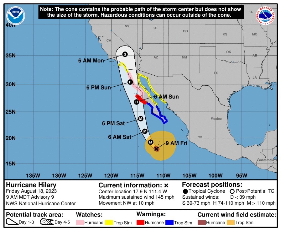
The border region of Tijuana-San Diego, which hasn't directly faced the impacts of a tropical storm since 1939, is preparing for the arrival of Hilary. This storm, rapidly advancing through the southern part of the Baja California Peninsula, could bring potentially damaging winds and rain, according to forecasts from the National Meteorological Service.
Hilary is expected to intensify into a hurricane by Thursday and generate local winds of up to 112.65 km/h, unleashing storms in the San Diego Bay. Computer projections indicate that the winds and rain will start on Saturday, but the storm won't make landfall until Sunday.
Antonio Rosquillas, former director of Civil Protection in Tijuana and Baja California, sounded the alarm about Hilary's trajectory. "The US Hurricane Center projects Hilary impacting Tijuana, Tecate, Rosarito, and Ensenada as a tropical storm around midnight on Sunday. It would be the first time these cities experience a direct impact of this kind."

It's important to note that San Diego has previously been affected by a hurricane on October 2, 1858, and a tropical storm on September 25, 1939. Both systems originated near Baja California, a region where waters are warm enough to fuel such phenomena.
On the other hand, Tropical Storm Kay surprised in September last year by reaching speeds of 241.4 km/h in San Diego, causing strong winds and rainfall in the area.
Hilary's rapid formation places it as a potential Category 3 hurricane threat with winds ranging from 178 to 207 km/h. Wednesday's projections indicate that by Saturday, Hilary's strong winds could increase the risk of forest fires in San Diego County. It's anticipated that by Monday, the rainfall will be heavier in mountains and deserts, possibly accumulating between 7.6 to 10 cm.
As it progresses, Hilary could generate waves of 1.5 to 2.5 meters in parts of San Diego County and breakers of 3 to 4.5 meters in areas of Orange County.
With the imminent arrival of Hilary, the population is advised to stay tuned to authorities' instructions and take precautions.

Cali - Baja
hace 2 minutos
Obtuvo 69 votos contra 64 de Gabriel Vizcaíno en una contienda reñida ..

Cali - Baja
hace 14 minutos
Jesús Alejandro Ruíz Uribe compartió este mensaje con representantes de diferentes medios de comunic ..

Deportes
hace 33 minutos
“Terrible” dijo lo que piensa de Juan José Ramírez, quien estuvo en el duelo Munguía vs. Surace ..

Cali - Baja
hace 43 minutos
Obras beneficiarán a más de 19 mil residentes de la delegación Otay Centenario y tienen una garantía ..

Cali - Baja
hace 1 hora
Al igual que los policías de Tecate y el Valle de Mexicali ..

Cali - Baja
hace 1 hora
Un estudio realizado por el instituto concluyó que estas albercas no son utilizadas de manera signif ..